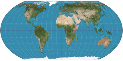
The United Nations has recently passed a resolution to endorse an updated approach to global cartography that aims to provide a more accurate representation of Africa’s size on world maps. This move comes after years of discussions regarding the misrepresentation of African landmass and its implications for geography education and global perception.
Background and context
The existing world maps, particularly the Mercator projection, have long been critiqued for distorting the true size of landmasses, particularly in the tropics. While this projection has been a standard for centuries, its inaccuracies can lead to misunderstandings regarding the scale and importance of various regions, especially Africa. In the Mercator projection, countries closer to the equator, like those in Africa, appear much smaller than they truly are, perpetuating an image that undermines their significance in global discussions.
Various studies and campaigns over the years have called for a reevaluation of how Africa is portrayed on world maps. Advocates argue that a more accurate depiction of the continent would not only reflect geographical realities but also combat stereotypes and misconceptions that often accompany its portrayal. The push for change gained momentum as more countries recognized the importance of accurate geographical representation in education, development, and global diplomacy.
Latest developments
This month, the UN General Assembly voted overwhelmingly to support the introduction of a new global map that will more accurately showcase Africa and its neighboring regions. The initiative is being spearheaded by several African nations that have long argued against the status quo. Proponents of the change emphasized that this is not merely a cosmetic adjustment but one that could shift the narrative surrounding Africa’s role on the international stage.
In addition to the endorsement from the UN, geographers and cartographers are now tasked with examining different projection methods that can enhance the visibility and representation of Africa. This includes a potential shift towards the Peters or Gall-Peters projection, both of which argue for a more equitable depiction of global landmasses.
What to watch next
The UN’s endorsement marks a significant turning point, but the road ahead involves careful implementation and public awareness campaigns. As cartographers begin to develop new maps, it will be essential for educational institutions and media outlets worldwide to adopt these updated representations in their curricula and publications. The response from global institutions, particularly in terms of incorporating new maps into their operational frameworks, will likely play a critical role in shaping public perception.
Moreover, the reactions from various countries and how they choose to incorporate these new visuals into their own geography teaching and international relations will be pivotal. By making a concerted effort to correct historical inaccuracies in mapping, the international community can foster a greater understanding of Africa’s true geographical significance, potentially leading to a healthier discourse about the continent’s contributions to global affairs.